var breeze_prefetch = {"local_url":"https:\/\/avpay.aero","ignore_remote_prefetch":"1","ignore_list":["\/cart-2\/","\/checkout\/","\/my-account\/","\/cart-2\/","\/checkout\/","\/wp-admin\/"]};
var _wpUtilSettings = {"ajax":{"url":"\/wp-admin\/admin-ajax.php"}};
https://avpay.aero/wp-includes/js/wp-util.min.js
var wc_add_to_cart_params = {"ajax_url":"\/wp-admin\/admin-ajax.php","wc_ajax_url":"\/?wc-ajax=%%endpoint%%","i18n_view_cart":"View cart","cart_url":"https:\/\/avpay.aero\/cart-2\/","is_cart":"","cart_redirect_after_add":"no"};
var wc_add_to_cart_variation_params = {"wc_ajax_url":"\/?wc-ajax=%%endpoint%%","i18n_no_matching_variations_text":"Sorry, no products matched your selection. Please choose a different combination.","i18n_make_a_selection_text":"Please select some product options before adding this product to your cart.","i18n_unavailable_text":"Sorry, this product is unavailable. Please choose a different combination."};
var wc_single_product_params = {"i18n_required_rating_text":"Please select a rating","review_rating_required":"yes","flexslider":{"rtl":false,"animation":"slide","smoothHeight":true,"directionNav":false,"controlNav":"thumbnails","slideshow":false,"animationSpeed":500,"animationLoop":false,"allowOneSlide":false},"zoom_enabled":"","zoom_options":[],"photoswipe_enabled":"1","photoswipe_options":{"shareEl":false,"closeOnScroll":false,"history":false,"hideAnimationDuration":0,"showAnimationDuration":0},"flexslider_enabled":"1"};
var cmplz_tcf = {"cmp_url":"https:\/\/avpay.aero\/wp-content\/uploads\/complianz\/","retention_string":"Retention in days","undeclared_string":"Not declared","isServiceSpecific":"1","excludedVendors":{"15":15,"46":46,"56":56,"66":66,"110":110,"119":119,"139":139,"141":141,"174":174,"192":192,"261":261,"262":262,"359":359,"375":375,"377":377,"387":387,"415":415,"427":427,"431":431,"435":435,"458":458,"462":462,"482":482,"508":508,"512":512,"521":521,"527":527,"528":528,"531":531,"544":544,"569":569,"581":581,"587":587,"626":626,"644":644,"667":667,"711":711,"713":713,"733":733,"734":734,"736":736,"748":748,"756":756,"776":776,"786":786,"806":806,"809":809,"822":822,"836":836,"856":856,"870":870,"873":873,"876":876,"879":879,"882":882,"888":888,"890":890,"894":894,"899":899,"908":908,"909":909,"923":923,"970":970,"975":975,"986":986,"988":988,"996":996,"1011":1011,"1015":1015,"1018":1018,"1022":1022,"1039":1039,"1044":1044,"1051":1051,"1075":1075,"1078":1078,"1079":1079,"1087":1087,"1094":1094,"1102":1102,"1107":1107,"1114":1114,"1115":1115,"1121":1121,"1123":1123,"1124":1124,"1139":1139,"1141":1141,"1149":1149,"1156":1156,"1164":1164,"1167":1167,"1173":1173,"1181":1181,"901":901,"1198":1198,"1199":1199,"1211":1211,"1216":1216},"purposes":[1,2,3,4,5,6,7,8,9,10,11,1],"specialPurposes":[1,2],"features":[1,2,3],"specialFeatures":[1,2],"publisherCountryCode":"GB","lspact":"N","ccpa_applies":"","ac_mode":"1","debug":"","prefix":"cmplz_"};
var woopack_config = {"ajaxurl":"https:\/\/avpay.aero\/wp-admin\/admin-ajax.php","page":0,"current_page":"https:\/\/avpay.aero\/company\/avidyne-corporation\/product\/ifd550-premium-fms-gps-nav-com\/","woo_url":"https:\/\/avpay.aero\/wp-content\/plugins\/woocommerce\/"};
( function() {
window.onpageshow = function( event ) {
// Defined window.wpforms means that a form exists on a page.
// If so and back/forward button has been clicked,
// force reload a page to prevent the submit button state stuck.
if ( typeof window.wpforms !== 'undefined' && event.persisted ) {
window.location.reload();
}
};
}() );
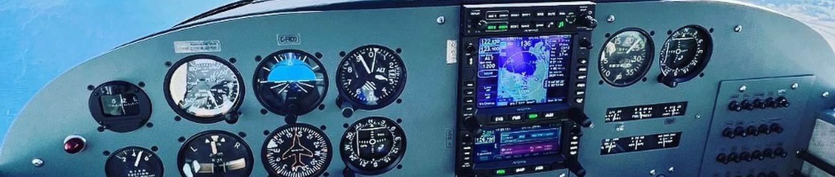
Avidyne’s top-of-the-line FMS/GPS Navigator, the IFD550 combines the latest touchscreen WAAS/SBAS/GPS/VHF navigation & communication with 3D SVS technology.
Avidyne is known in aviation circles for our innovative products & it’s no secret that safety & ease of use are true hallmarks of all Avidyne products. With the new top-of-the line IFD550 FMS/GPS/NAV/COM, Avidyne combines our latest in Hybrid Touch, WAAS/SBAS/GPS/VHF navigation & communication along with stunning 3D synthetic vision technology to deliver the most powerful & capable touchscreen, panel-mounted navigator ever made.
Just like the IFD440 & IFD540, the IFD550 delivers the features & functionality that makes the IFD Series popular with many pilots. Key features such as touchscreen with knobs & buttons, Page & Tab user interface, GeoFill, automatic waypoint nomination, & easy airway flight planning.
The IFD550 boasts is a 5.7” diagonal display with full VGA & 65,535 colours. Functional when flying in ultra bright sunlight, the LED backlighting makes the IFD550 display visible in any environmental condition.
Key Features Attitude Reference System (ARS) & Dynamic SVS Requiring no additional boxes or wiring, the IFD550 displays a three-dimensional scene representing “egocentric” (out-the-window) & “exocentric” (in trail) views of your aircraft in relation to nearby terrain & traffic.
3D Terrain & FLTA Terrain Awareness (SVS-TA) is provided via hashed coloration of terrain. Textual & aural alerts are provided for terrain hazards. Forward Looking Terrain Alerting (FLTA) provides an extra measure of safety by displaying a solid yellow or red impact point based on projected flight path in the event that a collision with terrain is projected. FLTA also provides visual CAS messaging & aural alerting.
Airport Flags Airfields are depicted with a METAR-style flag when in field of view. With valid METAR data from your datalink, airfield flags will be color-coded to represent the ceiling & visibility, consistent with the moving map presentation.
3D Traffic & Obstacles The IFD550 uses standard traffic symbology to indicate threat level by target size & relative altitude & bearing. Standard high, low & grouping symbology is used to clearly depict obstacles with color-coded threat bubbles based on hazard level.
At the heart of the IFD550’s synthetic vision system, is Avidyne’s fully-integrated, NextGen MEMS- Gyro ARS sensor that senses pitch & roll.
Introducing new Avidyne Vantage™ Flight Display Systems, a dual 12-inch diagonal PFD/MFD upgrade for General Aviation. Avidyne Vantage features synthetic…
To provide the best experiences, we and our partners use technologies like cookies to store and/or access device information. Consenting to these technologies will allow us and our partners to process personal data such as browsing behavior or unique IDs on this site and show (non-) personalized ads. Not consenting or withdrawing consent, may adversely affect certain features and functions.
Click below to consent to the above or make granular choices. Your choices will be applied to this site only. You can change your settings at any time, including withdrawing your consent, by using the toggles on the Cookie Policy, or by clicking on the manage consent button at the bottom of the screen.
Functional Always active
The technical storage or access is strictly necessary for the legitimate purpose of enabling the use of a specific service explicitly requested by the subscriber or user, or for the sole purpose of carrying out the transmission of a communication over an electronic communications network.
Preferences
The technical storage or access is necessary for the legitimate purpose of storing preferences that are not requested by the subscriber or user.
Statistics
The technical storage or access that is used exclusively for statistical purposes.The technical storage or access that is used exclusively for anonymous statistical purposes. Without a subpoena, voluntary compliance on the part of your Internet Service Provider, or additional records from a third party, information stored or retrieved for this purpose alone cannot usually be used to identify you.
Marketing
The technical storage or access is required to create user profiles to send advertising, or to track the user on a website or across several websites for similar marketing purposes.
To provide the best experiences, we use technologies like cookies to store and/or access device information. Consenting to these technologies will allow us to process data such as browsing behavior or unique IDs on this site. Not consenting or withdrawing consent, may adversely affect certain features and functions.
Functional Always active
The technical storage or access is strictly necessary for the legitimate purpose of enabling the use of a specific service explicitly requested by the subscriber or user, or for the sole purpose of carrying out the transmission of a communication over an electronic communications network.
Preferences
The technical storage or access is necessary for the legitimate purpose of storing preferences that are not requested by the subscriber or user.
Statistics
The technical storage or access that is used exclusively for statistical purposes.The technical storage or access that is used exclusively for anonymous statistical purposes. Without a subpoena, voluntary compliance on the part of your Internet Service Provider, or additional records from a third party, information stored or retrieved for this purpose alone cannot usually be used to identify you.
Marketing
The technical storage or access is required to create user profiles to send advertising, or to track the user on a website or across several websites for similar marketing purposes.
var wcpt_i18n = {"i18n_no_matching_variations_text":"Sorry, no products matched your selection. Please choose a different combination.","i18n_make_a_selection_text":"Please select some product options before adding this product to your cart.","i18n_unavailable_text":"Sorry, this product is unavailable. Please choose a different combination.","lang":""};
var wcpt_params = {"ajax_url":"https:\/\/avpay.aero\/wp-admin\/admin-ajax.php","wc_ajax_url":"\/?wc-ajax=%%endpoint%%","shop_url":"https:\/\/avpay.aero\/marketplace\/","shop_table_id":"82332","site_url":"https:\/\/avpay.aero","cart_widget_enabled_site_wide":"","cart_widget_exclude_urls":"","cart_widget_include_urls":"","initially_empty_cart":"1","initial_device":"laptop","breakpoints":{"tablet":"1199","phone":"749"},"price_decimals":"2","price_decimal_separator":".","price_thousand_separator":",","price_format":"%1$s%2$s","currency_symbol":"\u00a3","responsive_checkbox_trigger":"1"};
var wcpt_persist_params = ["s","post_type","term","taxonomy"];
var wcpt_ti_wishlist_url = "
https://avpay.aero/wishlist/";
var wcpt_ti_wishlist_ids = [];
var mejsL10n = {"language":"en","strings":{"mejs.download-file":"Download File","mejs.install-flash":"You are using a browser that does not have Flash player enabled or installed. Please turn on your Flash player plugin or download the latest version from https:\/\/get.adobe.com\/flashplayer\/","mejs.fullscreen":"Fullscreen","mejs.play":"Play","mejs.pause":"Pause","mejs.time-slider":"Time Slider","mejs.time-help-text":"Use Left\/Right Arrow keys to advance one second, Up\/Down arrows to advance ten seconds.","mejs.live-broadcast":"Live Broadcast","mejs.volume-help-text":"Use Up\/Down Arrow keys to increase or decrease volume.","mejs.unmute":"Unmute","mejs.mute":"Mute","mejs.volume-slider":"Volume Slider","mejs.video-player":"Video Player","mejs.audio-player":"Audio Player","mejs.captions-subtitles":"Captions\/Subtitles","mejs.captions-chapters":"Chapters","mejs.none":"None","mejs.afrikaans":"Afrikaans","mejs.albanian":"Albanian","mejs.arabic":"Arabic","mejs.belarusian":"Belarusian","mejs.bulgarian":"Bulgarian","mejs.catalan":"Catalan","mejs.chinese":"Chinese","mejs.chinese-simplified":"Chinese (Simplified)","mejs.chinese-traditional":"Chinese (Traditional)","mejs.croatian":"Croatian","mejs.czech":"Czech","mejs.danish":"Danish","mejs.dutch":"Dutch","mejs.english":"English","mejs.estonian":"Estonian","mejs.filipino":"Filipino","mejs.finnish":"Finnish","mejs.french":"French","mejs.galician":"Galician","mejs.german":"German","mejs.greek":"Greek","mejs.haitian-creole":"Haitian Creole","mejs.hebrew":"Hebrew","mejs.hindi":"Hindi","mejs.hungarian":"Hungarian","mejs.icelandic":"Icelandic","mejs.indonesian":"Indonesian","mejs.irish":"Irish","mejs.italian":"Italian","mejs.japanese":"Japanese","mejs.korean":"Korean","mejs.latvian":"Latvian","mejs.lithuanian":"Lithuanian","mejs.macedonian":"Macedonian","mejs.malay":"Malay","mejs.maltese":"Maltese","mejs.norwegian":"Norwegian","mejs.persian":"Persian","mejs.polish":"Polish","mejs.portuguese":"Portuguese","mejs.romanian":"Romanian","mejs.russian":"Russian","mejs.serbian":"Serbian","mejs.slovak":"Slovak","mejs.slovenian":"Slovenian","mejs.spanish":"Spanish","mejs.swahili":"Swahili","mejs.swedish":"Swedish","mejs.tagalog":"Tagalog","mejs.thai":"Thai","mejs.turkish":"Turkish","mejs.ukrainian":"Ukrainian","mejs.vietnamese":"Vietnamese","mejs.welsh":"Welsh","mejs.yiddish":"Yiddish"}};
var _wpmejsSettings = {"pluginPath":"\/wp-includes\/js\/mediaelement\/","classPrefix":"mejs-","stretching":"responsive","audioShortcodeLibrary":"mediaelement","videoShortcodeLibrary":"mediaelement"};
var wc_order_attribution = {"params":{"lifetime":1.0e-5,"session":30,"ajaxurl":"https:\/\/avpay.aero\/wp-admin\/admin-ajax.php","prefix":"wc_order_attribution_","allowTracking":false},"fields":{"source_type":"current.typ","referrer":"current_add.rf","utm_campaign":"current.cmp","utm_source":"current.src","utm_medium":"current.mdm","utm_content":"current.cnt","utm_id":"current.id","utm_term":"current.trm","session_entry":"current_add.ep","session_start_time":"current_add.fd","session_pages":"session.pgs","session_count":"udata.vst","user_agent":"udata.uag"}};
var woosc_vars = {"ajax_url":"https:\/\/avpay.aero\/wp-admin\/admin-ajax.php","nonce":"4e806a7ea8","hash":"oml3","user_id":"0cdb64fab32a05bd393b20c8c351de9f","page_url":"#","open_button":"","hide_empty_row":"yes","variations":"yes","open_button_action":"open_popup","menu_action":"open_popup","button_action":"show_table","sidebar_position":"right","message_position":"right-top","message_added":"{name} has been added to Compare list.","message_removed":"{name} has been removed from the Compare list.","message_exists":"{name} is already in the Compare list.","open_bar":"no","bar_bubble":"no","adding":"prepend","click_again":"no","hide_empty":"yes","click_outside":"yes","freeze_column":"yes","freeze_row":"yes","scrollbar":"yes","limit":"4","remove_all":"Do you want to remove all products from the compare?","limit_notice":"You can add a maximum of {limit} products to the comparison table.","copied_text":"Share link %s was copied to clipboard!","button_text":"Compare","button_text_added":"Compare","button_normal_icon":"woosc-icon-1","button_added_icon":"woosc-icon-74"};
var wc_cart_fragments_params = {"ajax_url":"\/wp-admin\/admin-ajax.php","wc_ajax_url":"\/?wc-ajax=%%endpoint%%","cart_hash_key":"wc_cart_hash_b6f0a4af5742f562436305e921d7ff3f","fragment_name":"wc_fragments_b6f0a4af5742f562436305e921d7ff3f","request_timeout":"5000"};
var tinvwl_add_to_wishlist = {"text_create":"Create New","text_already_in":"{product_name} already in Wishlist","simple_flow":"","hide_zero_counter":"","i18n_make_a_selection_text":"Please select some product options before adding this product to your wishlist.","tinvwl_break_submit":"No items or actions are selected.","tinvwl_clipboard":"Copied!","allow_parent_variable":"","block_ajax_wishlists_data":"","update_wishlists_data":"","hash_key":"ti_wishlist_data_b6f0a4af5742f562436305e921d7ff3f","nonce":"8d0d941d81","rest_root":"https:\/\/avpay.aero\/wp-json\/","plugin_url":"https:\/\/avpay.aero\/wp-content\/plugins\/ti-woocommerce-wishlist\/","wc_ajax_url":"\/?wc-ajax=tinvwl","stats":"","popup_timer":"6000"};
var wcfm_datepicker_params = {"closeText":"Done","currentText":"Today","monthNames":["January","February","March","April","May","June","July","August","September","October","November","December"],"monthNamesShort":["Jan","Feb","Mar","Apr","May","Jun","Jul","Aug","Sep","Oct","Nov","Dec"],"monthStatus":"Show a different month","dayNames":["Sunday","Monday","Tuesday","Wednesday","Thursday","Friday","Saturday"],"dayNamesShort":["Sun","Mon","Tue","Wed","Thu","Fri","Sat"],"dayNamesMin":["S","M","T","W","T","F","S"],"dateFormat":"MM dd, yy","firstDay":"1","isRTL":""};
var wcfm_core_dashboard_messages = {"product_approve_confirm":"Are you sure and want to approve \/ publish this 'Product'?","product_reject_confirm":"Are you sure and want to reject this 'Product'?\nReason:","product_archive_confirm":"Are you sure and want to archive this 'Product'?","multiblock_delete_confirm":"Are you sure and want to delete this 'Block'?\nYou can't undo this action ...","article_delete_confirm":"Are you sure and want to delete this 'Article'?\nYou can't undo this action ...","product_delete_confirm":"Are you sure and want to delete this 'Product'?\nYou can't undo this action ...","message_delete_confirm":"Are you sure and want to delete this 'Message'?\nYou can't undo this action ...","order_delete_confirm":"Are you sure and want to delete this 'Order'?\nYou can't undo this action ...","enquiry_delete_confirm":"Are you sure and want to delete this 'Enquiry'?\nYou can't undo this action ...","support_delete_confirm":"Are you sure and want to delete this 'Support Ticket'?\nYou can't undo this action ...","follower_delete_confirm":"Are you sure and want to delete this 'Follower'?\nYou can't undo this action ...","following_delete_confirm":"Are you sure and want to delete this 'Following'?\nYou can't undo this action ...","resource_delete_confirm":"Are you sure and want to delete this 'Resource'?\nYou can't undo this action ...","auction_bid_delete_confirm":"Are you sure and want to delete this 'Bid'?\nYou can't undo this action ...","order_mark_complete_confirm":"Are you sure and want to 'Mark as Complete' this Order?","booking_mark_complete_confirm":"Are you sure and want to 'Mark as Confirmed' this Booking?","booking_mark_decline_confirm":"Are you sure and want to 'Mark as Declined' this Booking?","appointment_mark_complete_confirm":"Are you sure and want to 'Mark as Complete' this Appointment?","add_new":"Add New","select_all":"Select all","select_none":"Select none","any_attribute":"Any","add_attribute_term":"Enter a name for the new attribute term:","wcfmu_upgrade_notice":"Please upgrade your WC Frontend Manager to Ultimate version and avail this feature.","pdf_invoice_upgrade_notice":"Install WC Frontend Manager Ultimate and WooCommerce PDF Invoices & Packing Slips to avail this feature.","wcfm_bulk_action_no_option":"Please select some element first!!","wcfm_bulk_action_confirm":"Are you sure and want to do this?\nYou can't undo this action ...","review_status_update_confirm":"Are you sure and want to do this?","everywhere":"Everywhere Else","required_message":"This field is required.","choose_select2":"Choose ","category_attribute_mapping":"All Attributes","search_page_select2":"Search for a page ...","search_attribute_select2":"Search for an attribute ...","search_product_select2":"Filter by product ...","search_taxonomy_select2":"Filter by category ...","choose_category_select2":"Choose Categories ...","choose_listings_select2":"Choose Listings ...","choose_tags_select2":"Choose Tags ...","choose_vendor_select2":"Choose Company ...","no_category_select2":"No categories","select2_searching":"Searching ...","select2_no_result":"No matching result found.","select2_loading_more":"Loading ...","select2_minimum_input":"Minimum input character ","wcfm_product_popup_next":"Next","wcfm_product_popup_previous":"Previous","wcfm_multiblick_addnew_help":"Add New Block","wcfm_multiblick_remove_help":"Remove Block","wcfm_multiblick_collapse_help":"Toggle Block","wcfm_multiblick_sortable_help":"Drag to re-arrange blocks","sell_this_item_confirm":"Do you want to add this item(s) to your store?","bulk_no_itm_selected":"Please select some product first!","user_non_logged_in":"Please login to the site first!","shiping_method_not_selected":"Please select a shipping method","shiping_method_not_found":"Shipping method not found","shiping_zone_not_found":"Shipping zone not found","shipping_method_del_confirm":"Are you sure you want to delete this 'Shipping Method'?\nYou can't undo this action ...","variation_auto_generate_confirm":"Are you sure you want to link all variations? This will create a new variation for each and every possible combination of variation attributes (max 50 per run)."};
var wcfm_params = {"ajax_url":"\/wp-admin\/admin-ajax.php","wc_ajax_url":"\/wp-admin\/admin-ajax.php","shop_url":"https:\/\/avpay.aero\/marketplace\/","wcfm_is_allow_wcfm":"","wcfm_is_vendor":"","is_user_logged_in":"","wcfm_allow_tinymce_options":"undo redo | insert | styleselect | bold italic | alignleft aligncenter alignright alignjustify | bullist numlist outdent indent | link image | ltr rtl","unread_message":"0","unread_enquiry":"0","wcfm_is_allow_new_message_check":"1","wcfm_new_message_check_duration":"300000","wcfm_is_desktop_notification":"1","is_mobile_desktop_notification":"","wcfm_is_allow_external_product_analytics":"","is_mobile":"","is_tablet":"","wcfm_ajax_nonce":"6808c481ed"};
var wcfm_enquiry_manage_messages = {"no_name":"Name is required.","no_email":"Email is required.","no_enquiry":"Please insert your Enquiry before submit.","no_reply":"Please insert your reply before submit.","enquiry_saved":"Your Enquiry successfully sent.","enquiry_published":"Enquiry reply successfully published.","enquiry_reply_saved":"Your reply successfully sent."};
var wcfmu_products_manage_messages = {"no_title":"Please insert Product Title before submit.","no_excerpt":"Please insert Product Short Description before submit.","no_description":"Please insert Product Description before submit.","sku_unique":"Product SKU must be unique.","variation_sku_unique":"Variation SKU must be unique.","product_saved":"Product Successfully Saved.","product_pending":"Product Successfully submitted for moderation.","product_published":"Product Successfully Published.","set_stock":"Set Stock","increase_stock":"Increase Stock","regular_price":"Regular Price","regular_price_increase":"Regular price increase by","regular_price_decrease":"Regular price decrease by","sales_price":"Sale Price","sales_price_increase":"Sale price increase by","sales_price_decrease":"Sale price decrease by","length":"Length","width":"Width","height":"Height","weight":"Weight","download_limit":"Download Limit","download_expiry":"Download Expiry"};
let cmplzBlockedContent = document.querySelector('.cmplz-blocked-content-notice');
if ( cmplzBlockedContent) {
cmplzBlockedContent.addEventListener('click', function(event) {
event.stopPropagation();
});
}
var wcpa_front = {"api_nonce":null,"root":"https:\/\/avpay.aero\/wp-json\/wcpa\/front\/","assets_url":"https:\/\/avpay.aero\/wp-content\/plugins\/woo-custom-product-addons-pro\/assets\/","date_format":"F j, Y","time_format":"H:i","validation_messages":{"uploadPending":"Files are being uploaded.","validNumberError":"Provide a valid number.","formError":"Fix the errors shown above","checkCaptcha":"Tick the \"I'm not a robot\" verification","requiredError":"Field is required","allowedCharsError":"Characters %s is not supported","patternError":"Pattern not matching","minlengthError":"Minimum %s characters required","maxlengthError":"Maximum %s characters allowed","minValueError":"Minimum value is %s","maxValueError":"Maximum value is %s","minFieldsError":"Select minimum %s fields","maxFieldsError":"Select maximum %s fields","maxFileCountError":"Maximum %s files allowed","minFileCountError":"Minimum %s files required","maxFileSizeError":"Maximum file size should be %s","minFileSizeError":"Minimum file size should be %s","fileExtensionError":"File type is not supported","quantityRequiredError":"Please enter a valid quantity","otherFieldError":"Other value required","charleftMessage":"%s characters left","validEmailError":"Provide a valid email address","validUrlError":"Provide a valid URL","minQuantityError":"Minimum quantity required is %s","maxQuantityError":"Maximum quantity allowed is %s","groupMinError":"Requires minimum %s","groupMaxError":"Allowed maximum %s","uploadError":"Failed to upload %s","gt_translate_keys":["uploadPending","validNumberError","formError","checkCaptcha","requiredError","allowedCharsError","patternError","minlengthError","maxlengthError","minValueError","maxValueError","minFieldsError","maxFieldsError","maxFileCountError","minFileCountError","maxFileSizeError","minFileSizeError","fileExtensionError","quantityRequiredError","otherFieldError","charleftMessage","validEmailError","validUrlError","minQuantityError","maxQuantityError","groupMinError","groupMaxError","uploadError"]},"google_map_api":"","reCAPTCHA_site_key":"","recaptcha_v":"v2","ajax_add_to_cart":"","summary_order":["option_price","product_price","fee","discount","total_price"],"change_price_as_quantity":"1","show_field_price_x_quantity":"","disable_validation_scroll":"","gallery_update_field":"last_field","update_top_price":"","datepicker_disableMobile":"","radio_unselect_img":"","strings":{"place_selector_street":"Street Address","place_selector_city":"City","place_selector_state":"State","place_selector_zip":"Zip Code","place_selector_country":"Country","place_selector_latitude":"Latitude","place_selector_longitude":"Longitude","file_button_text":"Choose File","file_placeholder":"{count} Files","file_droppable_action_text":"Browse","file_droppable_desc_text":"or {action} to choose a file","file_upload_completed":"Completed","file_upload_failed":"Failed to upload","other":"Other","clearSelection":"Clear Selection","repeater_add":"Add Field","repeater_remove":"Remove Field","file_droppable_text":"Drag and Drop Files Here","to":" to ","gt_translate_keys":["place_selector_street","place_selector_city","place_selector_state","place_selector_zip","place_selector_country","place_selector_latitude","place_selector_longitude","file_button_text","file_placeholder","file_droppable_action_text","file_droppable_desc_text","file_upload_completed","file_upload_failed","other","clearSelection","repeater_add","repeater_remove","file_droppable_text","to"]},"i18n_view_cart":"View cart","options_price_format":"(price)","wc_price_format":"%1$s%2$s","hide_option_price_zero":"1","discount_show_field_price":"1","discount_strike_field_price":"1","discount_strike_summary_price":"1","discount_strike_total_price":"1","responsive_layout":"","product_price_parent_selector":".summary","accordion_open":"first_opened","accordion_auto_open":"","accordion_auto_close":"","woo_price_suffix":"","prices_include_tax":"1","isAdmin":"","cart_url":"https:\/\/avpay.aero\/cart-2\/","is_cart":"","user_roles":["guest"],"google_map_countries":"","init_triggers":["wcpt_product_modal_ready","qv_loader_stop","quick_view_pro:load","elementor\/popup\/show","xt_wooqv-product-loaded","woodmart-quick-view-displayed","porto_init_countdown","woopack.quickview.ajaxload","quick-view-displayed","update_lazyload","riode_load","yith_infs_added_elem","jet-popup\/show-event\/after-show","etheme_quick_view_content_loaded","wc_backbone_modal_loaded"],"wc_currency_symbol":"\u00a3","wc_currency_symbol_raw":"\u00a3","wc_thousand_sep":",","wc_price_decimals":"2","price_format":"%1$s%2$s","wc_decimal_sep":".","wc_currency_pos":"left","mc_unit":"1","addons":[],"upload_method":"normal"};