var breeze_prefetch = {"local_url":"https:\/\/avpay.aero","ignore_remote_prefetch":"1","ignore_list":["\/cart-2\/","\/checkout\/","\/my-account\/","\/cart-2\/","\/checkout\/","\/wp-admin\/"]};
var _wpUtilSettings = {"ajax":{"url":"\/wp-admin\/admin-ajax.php"}};
https://avpay.aero/wp-includes/js/wp-util.min.js
var wc_add_to_cart_params = {"ajax_url":"\/wp-admin\/admin-ajax.php","wc_ajax_url":"\/?wc-ajax=%%endpoint%%","i18n_view_cart":"View cart","cart_url":"https:\/\/avpay.aero\/cart-2\/","is_cart":"","cart_redirect_after_add":"no"};
var wc_add_to_cart_variation_params = {"wc_ajax_url":"\/?wc-ajax=%%endpoint%%","i18n_no_matching_variations_text":"Sorry, no products matched your selection. Please choose a different combination.","i18n_make_a_selection_text":"Please select some product options before adding this product to your cart.","i18n_unavailable_text":"Sorry, this product is unavailable. Please choose a different combination."};
var cmplz_tcf = {"cmp_url":"https:\/\/avpay.aero\/wp-content\/uploads\/complianz\/","retention_string":"Retention in days","undeclared_string":"Not declared","isServiceSpecific":"1","excludedVendors":{"15":15,"46":46,"56":56,"66":66,"110":110,"119":119,"139":139,"141":141,"174":174,"192":192,"261":261,"262":262,"359":359,"375":375,"377":377,"387":387,"415":415,"427":427,"431":431,"435":435,"458":458,"462":462,"482":482,"508":508,"512":512,"521":521,"527":527,"528":528,"531":531,"544":544,"569":569,"581":581,"587":587,"626":626,"644":644,"667":667,"711":711,"713":713,"733":733,"734":734,"736":736,"748":748,"756":756,"776":776,"786":786,"806":806,"809":809,"822":822,"836":836,"856":856,"870":870,"873":873,"876":876,"879":879,"882":882,"888":888,"890":890,"894":894,"899":899,"908":908,"909":909,"923":923,"970":970,"975":975,"986":986,"988":988,"996":996,"1011":1011,"1015":1015,"1018":1018,"1022":1022,"1039":1039,"1044":1044,"1051":1051,"1075":1075,"1078":1078,"1079":1079,"1087":1087,"1094":1094,"1102":1102,"1107":1107,"1114":1114,"1115":1115,"1121":1121,"1123":1123,"1124":1124,"1139":1139,"1141":1141,"1149":1149,"1156":1156,"1164":1164,"1167":1167,"1173":1173,"1181":1181,"901":901,"1198":1198,"1199":1199,"1211":1211,"1216":1216},"purposes":[1,2,3,4,5,6,7,8,9,10,11,1],"specialPurposes":[1,2],"features":[1,2,3],"specialFeatures":[1,2],"publisherCountryCode":"GB","lspact":"N","ccpa_applies":"","ac_mode":"1","debug":"","prefix":"cmplz_"};
var woopack_config = {"ajaxurl":"https:\/\/avpay.aero\/wp-admin\/admin-ajax.php","page":0,"current_page":"https:\/\/avpay.aero\/company\/uk56-geoview-drones\/","woo_url":"https:\/\/avpay.aero\/wp-content\/plugins\/woocommerce\/"};
( function() {
window.onpageshow = function( event ) {
// Defined window.wpforms means that a form exists on a page.
// If so and back/forward button has been clicked,
// force reload a page to prevent the submit button state stuck.
if ( typeof window.wpforms !== 'undefined' && event.persisted ) {
window.location.reload();
}
};
}() );
GeoView Drones provides professional, bespoke, high quality drone services to our clients throughout North Wales and Nationwide.
Our aerial photography, videography and surveys cover a multitude of applications, and our services offer complete flexibility, as we tailor them to your specific requirements and budget.
Beginning with initial enquiry and quotation, we undertake detailed risk assessments and pre-site surveys, executing safe and professional flight operations, with timely delivery of high quality digital aerial media and geospatial data.
No products were found matching your selection.
Services
Aerial Photography
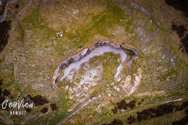
GeoView Drones specialise in unique and visually stunning aerial photography, utilising the latest in drone technology and skilled editing, perfect for framing as high quality fine art digital prints, and bespoke wall art pieces in a variety of options and finishes.
We regularly update our social media feeds with our latest work, so feel free to explore below, and get in touch if you would like to purchase or commission any of our work!
Aerial Videography
GeoView Drones provides high quality, 4K resolution videography from both standard and FPV (First Person View) drones, providing the full range of options for silky smooth cinematic and eye-popping dynamic footage. These come with full post production including editing and colour correction.
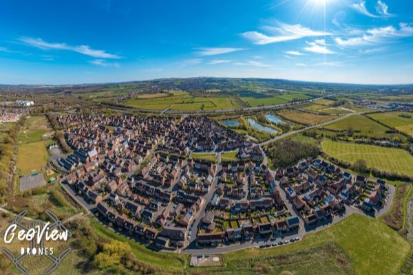
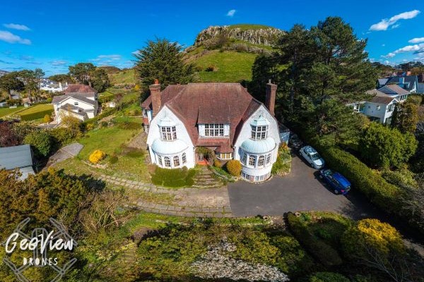
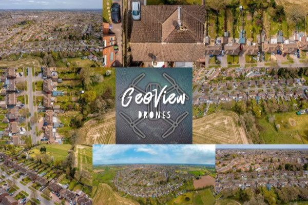
Property Aerial Media
Drone acquired aerial imagery and footage is the leading way to market your business premises or property. If you’re looking for bespoke digital content for your company’s website or social media, or listing your house for sale/holiday home for rental online, we can help. An eye in the sky contextualises your premises/property within its wider surroundings, giving potential customers, buyers or renters a true feel for its location and layout, something ground based photography, or Google maps satellite imagery, simply cannot equally convey. Our CAA Approved Permissions and Public Liability Insurance allows us to legally and safely operate over and within 150m of property and people, something that is otherwise against the law. We provide complete digital post-processing, including colour correction and can include boundary/perimeter mark-ups. Our 360° aerial panoramas can include informative points of interest along with links to property listings/websites, creating truly interactive and engaging content guaranteed to get noticed!
Aerial Inspection
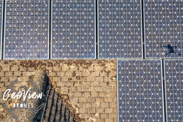
Keeping your home, holiday rental property or commercial premises in top condition, often involves keeping up with maintenance. A drone survey is a simple and effective means of inspection, to determine if potentially costly repairs are required. We provide timely and thorough aerial inspections, to assist in condition assessment of your roofline/chimney/slate/lead flashing/pointing, providing you with the photographic and/or videographic evidence required to assess if remedial work needs carrying out.
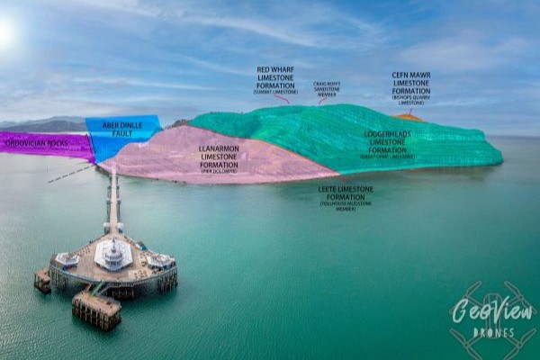
3D Aerial Surveys
Whether you’re a land surveyor, property developer or site investigator, our bespoke aerial surveys capture the key milestones in your project’s timeline. Our drone technology provides consistent, reliable and replicable aerial surveys, an effective method of keeping detailed photographic and videographic records, as your project or development progresses. With our advanced photogrammetry service, 3D modelling provides a powerful and immersive tool to remotely explore and extract geospatial and dimensional data from your site, with the addition of subsequent milestone surveys to capture temporal data, allowing you to analyse changes through time.
Site Mapping
For large areas, producing a geospatially accurate maps of your propert using ground-based surveying is a lengthy and therefore costly exercise. Our bespoke drone based mapping service delivers accurate super high-resolution orthomosaic projections and Digital Terrain Models (DTMs) of your entire site.
Events, Weddings & Family Photoshoots
Planning an outdoor event, your wedding day, or a unique family photoshoot? GeoView Drones provides the services to record these memorable moments with birds eye view imagery and footage. We provide complete digital image post-processing and video production, delivering you the best possible package to suit your requirements and budget.
Gallery
×
Manage Cookie Consent
To provide the best experiences, we and our partners use technologies like cookies to store and/or access device information. Consenting to these technologies will allow us and our partners to process personal data such as browsing behavior or unique IDs on this site and show (non-) personalized ads. Not consenting or withdrawing consent, may adversely affect certain features and functions.
Click below to consent to the above or make granular choices. Your choices will be applied to this site only. You can change your settings at any time, including withdrawing your consent, by using the toggles on the Cookie Policy, or by clicking on the manage consent button at the bottom of the screen.
Functional Always active
The technical storage or access is strictly necessary for the legitimate purpose of enabling the use of a specific service explicitly requested by the subscriber or user, or for the sole purpose of carrying out the transmission of a communication over an electronic communications network.
Preferences
The technical storage or access is necessary for the legitimate purpose of storing preferences that are not requested by the subscriber or user.
Statistics
The technical storage or access that is used exclusively for statistical purposes.The technical storage or access that is used exclusively for anonymous statistical purposes. Without a subpoena, voluntary compliance on the part of your Internet Service Provider, or additional records from a third party, information stored or retrieved for this purpose alone cannot usually be used to identify you.
Marketing
The technical storage or access is required to create user profiles to send advertising, or to track the user on a website or across several websites for similar marketing purposes.
To provide the best experiences, we use technologies like cookies to store and/or access device information. Consenting to these technologies will allow us to process data such as browsing behavior or unique IDs on this site. Not consenting or withdrawing consent, may adversely affect certain features and functions.
Functional Always active
The technical storage or access is strictly necessary for the legitimate purpose of enabling the use of a specific service explicitly requested by the subscriber or user, or for the sole purpose of carrying out the transmission of a communication over an electronic communications network.
Preferences
The technical storage or access is necessary for the legitimate purpose of storing preferences that are not requested by the subscriber or user.
Statistics
The technical storage or access that is used exclusively for statistical purposes.The technical storage or access that is used exclusively for anonymous statistical purposes. Without a subpoena, voluntary compliance on the part of your Internet Service Provider, or additional records from a third party, information stored or retrieved for this purpose alone cannot usually be used to identify you.
Marketing
The technical storage or access is required to create user profiles to send advertising, or to track the user on a website or across several websites for similar marketing purposes.
var wcpt_i18n = {"i18n_no_matching_variations_text":"Sorry, no products matched your selection. Please choose a different combination.","i18n_make_a_selection_text":"Please select some product options before adding this product to your cart.","i18n_unavailable_text":"Sorry, this product is unavailable. Please choose a different combination.","lang":""};
var wcpt_params = {"ajax_url":"https:\/\/avpay.aero\/wp-admin\/admin-ajax.php","wc_ajax_url":"\/?wc-ajax=%%endpoint%%","shop_url":"https:\/\/avpay.aero\/marketplace\/","shop_table_id":"82332","site_url":"https:\/\/avpay.aero","cart_widget_enabled_site_wide":"","cart_widget_exclude_urls":"","cart_widget_include_urls":"","initially_empty_cart":"1","initial_device":"laptop","breakpoints":{"tablet":"1199","phone":"749"},"price_decimals":"2","price_decimal_separator":".","price_thousand_separator":",","price_format":"%1$s%2$s","currency_symbol":"\u00a3","responsive_checkbox_trigger":"1"};
var wcpt_persist_params = ["s","post_type","term","taxonomy"];
var wcpt_ti_wishlist_url = "
https://avpay.aero/wishlist/";
var wcpt_ti_wishlist_ids = [];
var mejsL10n = {"language":"en","strings":{"mejs.download-file":"Download File","mejs.install-flash":"You are using a browser that does not have Flash player enabled or installed. Please turn on your Flash player plugin or download the latest version from https:\/\/get.adobe.com\/flashplayer\/","mejs.fullscreen":"Fullscreen","mejs.play":"Play","mejs.pause":"Pause","mejs.time-slider":"Time Slider","mejs.time-help-text":"Use Left\/Right Arrow keys to advance one second, Up\/Down arrows to advance ten seconds.","mejs.live-broadcast":"Live Broadcast","mejs.volume-help-text":"Use Up\/Down Arrow keys to increase or decrease volume.","mejs.unmute":"Unmute","mejs.mute":"Mute","mejs.volume-slider":"Volume Slider","mejs.video-player":"Video Player","mejs.audio-player":"Audio Player","mejs.captions-subtitles":"Captions\/Subtitles","mejs.captions-chapters":"Chapters","mejs.none":"None","mejs.afrikaans":"Afrikaans","mejs.albanian":"Albanian","mejs.arabic":"Arabic","mejs.belarusian":"Belarusian","mejs.bulgarian":"Bulgarian","mejs.catalan":"Catalan","mejs.chinese":"Chinese","mejs.chinese-simplified":"Chinese (Simplified)","mejs.chinese-traditional":"Chinese (Traditional)","mejs.croatian":"Croatian","mejs.czech":"Czech","mejs.danish":"Danish","mejs.dutch":"Dutch","mejs.english":"English","mejs.estonian":"Estonian","mejs.filipino":"Filipino","mejs.finnish":"Finnish","mejs.french":"French","mejs.galician":"Galician","mejs.german":"German","mejs.greek":"Greek","mejs.haitian-creole":"Haitian Creole","mejs.hebrew":"Hebrew","mejs.hindi":"Hindi","mejs.hungarian":"Hungarian","mejs.icelandic":"Icelandic","mejs.indonesian":"Indonesian","mejs.irish":"Irish","mejs.italian":"Italian","mejs.japanese":"Japanese","mejs.korean":"Korean","mejs.latvian":"Latvian","mejs.lithuanian":"Lithuanian","mejs.macedonian":"Macedonian","mejs.malay":"Malay","mejs.maltese":"Maltese","mejs.norwegian":"Norwegian","mejs.persian":"Persian","mejs.polish":"Polish","mejs.portuguese":"Portuguese","mejs.romanian":"Romanian","mejs.russian":"Russian","mejs.serbian":"Serbian","mejs.slovak":"Slovak","mejs.slovenian":"Slovenian","mejs.spanish":"Spanish","mejs.swahili":"Swahili","mejs.swedish":"Swedish","mejs.tagalog":"Tagalog","mejs.thai":"Thai","mejs.turkish":"Turkish","mejs.ukrainian":"Ukrainian","mejs.vietnamese":"Vietnamese","mejs.welsh":"Welsh","mejs.yiddish":"Yiddish"}};
var _wpmejsSettings = {"pluginPath":"\/wp-includes\/js\/mediaelement\/","classPrefix":"mejs-","stretching":"responsive","audioShortcodeLibrary":"mediaelement","videoShortcodeLibrary":"mediaelement"};
var wc_order_attribution = {"params":{"lifetime":1.0e-5,"session":30,"ajaxurl":"https:\/\/avpay.aero\/wp-admin\/admin-ajax.php","prefix":"wc_order_attribution_","allowTracking":false},"fields":{"source_type":"current.typ","referrer":"current_add.rf","utm_campaign":"current.cmp","utm_source":"current.src","utm_medium":"current.mdm","utm_content":"current.cnt","utm_id":"current.id","utm_term":"current.trm","session_entry":"current_add.ep","session_start_time":"current_add.fd","session_pages":"session.pgs","session_count":"udata.vst","user_agent":"udata.uag"}};
var woosc_vars = {"ajax_url":"https:\/\/avpay.aero\/wp-admin\/admin-ajax.php","nonce":"d0ab480cae","hash":"oml3","user_id":"0cdb64fab32a05bd393b20c8c351de9f","page_url":"#","open_button":"","hide_empty_row":"yes","variations":"yes","open_button_action":"open_popup","menu_action":"open_popup","button_action":"show_table","sidebar_position":"right","message_position":"right-top","message_added":"{name} has been added to Compare list.","message_removed":"{name} has been removed from the Compare list.","message_exists":"{name} is already in the Compare list.","open_bar":"no","bar_bubble":"no","adding":"prepend","click_again":"no","hide_empty":"yes","click_outside":"yes","freeze_column":"yes","freeze_row":"yes","scrollbar":"yes","limit":"4","remove_all":"Do you want to remove all products from the compare?","limit_notice":"You can add a maximum of {limit} products to the comparison table.","copied_text":"Share link %s was copied to clipboard!","button_text":"Compare","button_text_added":"Compare","button_normal_icon":"woosc-icon-1","button_added_icon":"woosc-icon-74"};
var wc_cart_fragments_params = {"ajax_url":"\/wp-admin\/admin-ajax.php","wc_ajax_url":"\/?wc-ajax=%%endpoint%%","cart_hash_key":"wc_cart_hash_b6f0a4af5742f562436305e921d7ff3f","fragment_name":"wc_fragments_b6f0a4af5742f562436305e921d7ff3f","request_timeout":"5000"};
var tinvwl_add_to_wishlist = {"text_create":"Create New","text_already_in":"{product_name} already in Wishlist","simple_flow":"","hide_zero_counter":"","i18n_make_a_selection_text":"Please select some product options before adding this product to your wishlist.","tinvwl_break_submit":"No items or actions are selected.","tinvwl_clipboard":"Copied!","allow_parent_variable":"","block_ajax_wishlists_data":"","update_wishlists_data":"","hash_key":"ti_wishlist_data_b6f0a4af5742f562436305e921d7ff3f","nonce":"3934915d5a","rest_root":"https:\/\/avpay.aero\/wp-json\/","plugin_url":"https:\/\/avpay.aero\/wp-content\/plugins\/ti-woocommerce-wishlist\/","wc_ajax_url":"\/?wc-ajax=tinvwl","stats":"","popup_timer":"6000"};
var wcfm_datepicker_params = {"closeText":"Done","currentText":"Today","monthNames":["January","February","March","April","May","June","July","August","September","October","November","December"],"monthNamesShort":["Jan","Feb","Mar","Apr","May","Jun","Jul","Aug","Sep","Oct","Nov","Dec"],"monthStatus":"Show a different month","dayNames":["Sunday","Monday","Tuesday","Wednesday","Thursday","Friday","Saturday"],"dayNamesShort":["Sun","Mon","Tue","Wed","Thu","Fri","Sat"],"dayNamesMin":["S","M","T","W","T","F","S"],"dateFormat":"MM dd, yy","firstDay":"1","isRTL":""};
var wcfm_datepicker_params = {"closeText":"Done","currentText":"Today","monthNames":["January","February","March","April","May","June","July","August","September","October","November","December"],"monthNamesShort":["Jan","Feb","Mar","Apr","May","Jun","Jul","Aug","Sep","Oct","Nov","Dec"],"monthStatus":"Show a different month","dayNames":["Sunday","Monday","Tuesday","Wednesday","Thursday","Friday","Saturday"],"dayNamesShort":["Sun","Mon","Tue","Wed","Thu","Fri","Sat"],"dayNamesMin":["S","M","T","W","T","F","S"],"dateFormat":"MM dd, yy","firstDay":"1","isRTL":""};
var wcfm_core_dashboard_messages = {"product_approve_confirm":"Are you sure and want to approve \/ publish this 'Product'?","product_reject_confirm":"Are you sure and want to reject this 'Product'?\nReason:","product_archive_confirm":"Are you sure and want to archive this 'Product'?","multiblock_delete_confirm":"Are you sure and want to delete this 'Block'?\nYou can't undo this action ...","article_delete_confirm":"Are you sure and want to delete this 'Article'?\nYou can't undo this action ...","product_delete_confirm":"Are you sure and want to delete this 'Product'?\nYou can't undo this action ...","message_delete_confirm":"Are you sure and want to delete this 'Message'?\nYou can't undo this action ...","order_delete_confirm":"Are you sure and want to delete this 'Order'?\nYou can't undo this action ...","enquiry_delete_confirm":"Are you sure and want to delete this 'Enquiry'?\nYou can't undo this action ...","support_delete_confirm":"Are you sure and want to delete this 'Support Ticket'?\nYou can't undo this action ...","follower_delete_confirm":"Are you sure and want to delete this 'Follower'?\nYou can't undo this action ...","following_delete_confirm":"Are you sure and want to delete this 'Following'?\nYou can't undo this action ...","resource_delete_confirm":"Are you sure and want to delete this 'Resource'?\nYou can't undo this action ...","auction_bid_delete_confirm":"Are you sure and want to delete this 'Bid'?\nYou can't undo this action ...","order_mark_complete_confirm":"Are you sure and want to 'Mark as Complete' this Order?","booking_mark_complete_confirm":"Are you sure and want to 'Mark as Confirmed' this Booking?","booking_mark_decline_confirm":"Are you sure and want to 'Mark as Declined' this Booking?","appointment_mark_complete_confirm":"Are you sure and want to 'Mark as Complete' this Appointment?","add_new":"Add New","select_all":"Select all","select_none":"Select none","any_attribute":"Any","add_attribute_term":"Enter a name for the new attribute term:","wcfmu_upgrade_notice":"Please upgrade your WC Frontend Manager to Ultimate version and avail this feature.","pdf_invoice_upgrade_notice":"Install WC Frontend Manager Ultimate and WooCommerce PDF Invoices & Packing Slips to avail this feature.","wcfm_bulk_action_no_option":"Please select some element first!!","wcfm_bulk_action_confirm":"Are you sure and want to do this?\nYou can't undo this action ...","review_status_update_confirm":"Are you sure and want to do this?","everywhere":"Everywhere Else","required_message":"This field is required.","choose_select2":"Choose ","category_attribute_mapping":"All Attributes","search_page_select2":"Search for a page ...","search_attribute_select2":"Search for an attribute ...","search_product_select2":"Filter by product ...","search_taxonomy_select2":"Filter by category ...","choose_category_select2":"Choose Categories ...","choose_listings_select2":"Choose Listings ...","choose_tags_select2":"Choose Tags ...","choose_vendor_select2":"Choose Company ...","no_category_select2":"No categories","select2_searching":"Searching ...","select2_no_result":"No matching result found.","select2_loading_more":"Loading ...","select2_minimum_input":"Minimum input character ","wcfm_product_popup_next":"Next","wcfm_product_popup_previous":"Previous","wcfm_multiblick_addnew_help":"Add New Block","wcfm_multiblick_remove_help":"Remove Block","wcfm_multiblick_collapse_help":"Toggle Block","wcfm_multiblick_sortable_help":"Drag to re-arrange blocks","sell_this_item_confirm":"Do you want to add this item(s) to your store?","bulk_no_itm_selected":"Please select some product first!","user_non_logged_in":"Please login to the site first!","shiping_method_not_selected":"Please select a shipping method","shiping_method_not_found":"Shipping method not found","shiping_zone_not_found":"Shipping zone not found","shipping_method_del_confirm":"Are you sure you want to delete this 'Shipping Method'?\nYou can't undo this action ...","variation_auto_generate_confirm":"Are you sure you want to link all variations? This will create a new variation for each and every possible combination of variation attributes (max 50 per run)."};
var wcfm_params = {"ajax_url":"\/wp-admin\/admin-ajax.php","wc_ajax_url":"\/wp-admin\/admin-ajax.php","shop_url":"https:\/\/avpay.aero\/marketplace\/","wcfm_is_allow_wcfm":"","wcfm_is_vendor":"","is_user_logged_in":"","wcfm_allow_tinymce_options":"undo redo | insert | styleselect | bold italic | alignleft aligncenter alignright alignjustify | bullist numlist outdent indent | link image | ltr rtl","unread_message":"0","unread_enquiry":"0","wcfm_is_allow_new_message_check":"1","wcfm_new_message_check_duration":"300000","wcfm_is_desktop_notification":"1","is_mobile_desktop_notification":"","wcfm_is_allow_external_product_analytics":"","is_mobile":"","is_tablet":"","wcfm_ajax_nonce":"5bbd3c0580"};
var wcfm_enquiry_manage_messages = {"no_name":"Name is required.","no_email":"Email is required.","no_enquiry":"Please insert your Enquiry before submit.","no_reply":"Please insert your reply before submit.","enquiry_saved":"Your Enquiry successfully sent.","enquiry_published":"Enquiry reply successfully published.","enquiry_reply_saved":"Your reply successfully sent."};
var wcfmu_products_manage_messages = {"no_title":"Please insert Product Title before submit.","no_excerpt":"Please insert Product Short Description before submit.","no_description":"Please insert Product Description before submit.","sku_unique":"Product SKU must be unique.","variation_sku_unique":"Variation SKU must be unique.","product_saved":"Product Successfully Saved.","product_pending":"Product Successfully submitted for moderation.","product_published":"Product Successfully Published.","set_stock":"Set Stock","increase_stock":"Increase Stock","regular_price":"Regular Price","regular_price_increase":"Regular price increase by","regular_price_decrease":"Regular price decrease by","sales_price":"Sale Price","sales_price_increase":"Sale price increase by","sales_price_decrease":"Sale price decrease by","length":"Length","width":"Width","height":"Height","weight":"Weight","download_limit":"Download Limit","download_expiry":"Download Expiry"};
var wcfm_reviews_messages = {"no_comment":"Please insert your comment before submit.","no_rating":"Please rate atleast one category before submit.","review_saved":"Your review successfully submited, will publish after approval!","review_published":"Your review successfully submited.","review_response_saved":"Your review response successfully submited.","refund_requests_failed":"Your refund request failed, please try after sometime.","refund_requests_approved":"Refund requests successfully approved."};
var wcfm_slider_banner_delay = {"delay":"4000"};
var wcfmmp_store_map_options = {"default_lat":"53.5616654","default_lng":"-2.327565","default_zoom":"10","store_icon":"https:\/\/avpay.aero\/wp-content\/plugins\/wc-multivendor-marketplace\/assets\/images\/wcfmmp_map_icon.png","icon_width":"40","icon_height":"57","is_poi":"1","is_allow_scroll_zoom":"1","is_rtl":""};
let cmplzBlockedContent = document.querySelector('.cmplz-blocked-content-notice');
if ( cmplzBlockedContent) {
cmplzBlockedContent.addEventListener('click', function(event) {
event.stopPropagation();
});
}
var wcpa_front = {"api_nonce":null,"root":"https:\/\/avpay.aero\/wp-json\/wcpa\/front\/","assets_url":"https:\/\/avpay.aero\/wp-content\/plugins\/woo-custom-product-addons-pro\/assets\/","date_format":"F j, Y","time_format":"H:i","validation_messages":{"uploadPending":"Files are being uploaded.","validNumberError":"Provide a valid number.","formError":"Fix the errors shown above","checkCaptcha":"Tick the \"I'm not a robot\" verification","requiredError":"Field is required","allowedCharsError":"Characters %s is not supported","patternError":"Pattern not matching","minlengthError":"Minimum %s characters required","maxlengthError":"Maximum %s characters allowed","minValueError":"Minimum value is %s","maxValueError":"Maximum value is %s","minFieldsError":"Select minimum %s fields","maxFieldsError":"Select maximum %s fields","maxFileCountError":"Maximum %s files allowed","minFileCountError":"Minimum %s files required","maxFileSizeError":"Maximum file size should be %s","minFileSizeError":"Minimum file size should be %s","fileExtensionError":"File type is not supported","quantityRequiredError":"Please enter a valid quantity","otherFieldError":"Other value required","charleftMessage":"%s characters left","validEmailError":"Provide a valid email address","validUrlError":"Provide a valid URL","minQuantityError":"Minimum quantity required is %s","maxQuantityError":"Maximum quantity allowed is %s","groupMinError":"Requires minimum %s","groupMaxError":"Allowed maximum %s","uploadError":"Failed to upload %s","gt_translate_keys":["uploadPending","validNumberError","formError","checkCaptcha","requiredError","allowedCharsError","patternError","minlengthError","maxlengthError","minValueError","maxValueError","minFieldsError","maxFieldsError","maxFileCountError","minFileCountError","maxFileSizeError","minFileSizeError","fileExtensionError","quantityRequiredError","otherFieldError","charleftMessage","validEmailError","validUrlError","minQuantityError","maxQuantityError","groupMinError","groupMaxError","uploadError"]},"google_map_api":"","reCAPTCHA_site_key":"","recaptcha_v":"v2","ajax_add_to_cart":"","summary_order":["option_price","product_price","fee","discount","total_price"],"change_price_as_quantity":"1","show_field_price_x_quantity":"","disable_validation_scroll":"","gallery_update_field":"last_field","update_top_price":"","datepicker_disableMobile":"","radio_unselect_img":"","strings":{"place_selector_street":"Street Address","place_selector_city":"City","place_selector_state":"State","place_selector_zip":"Zip Code","place_selector_country":"Country","place_selector_latitude":"Latitude","place_selector_longitude":"Longitude","file_button_text":"Choose File","file_placeholder":"{count} Files","file_droppable_action_text":"Browse","file_droppable_desc_text":"or {action} to choose a file","file_upload_completed":"Completed","file_upload_failed":"Failed to upload","other":"Other","clearSelection":"Clear Selection","repeater_add":"Add Field","repeater_remove":"Remove Field","file_droppable_text":"Drag and Drop Files Here","to":" to ","gt_translate_keys":["place_selector_street","place_selector_city","place_selector_state","place_selector_zip","place_selector_country","place_selector_latitude","place_selector_longitude","file_button_text","file_placeholder","file_droppable_action_text","file_droppable_desc_text","file_upload_completed","file_upload_failed","other","clearSelection","repeater_add","repeater_remove","file_droppable_text","to"]},"i18n_view_cart":"View cart","options_price_format":"(price)","wc_price_format":"%1$s%2$s","hide_option_price_zero":"1","discount_show_field_price":"1","discount_strike_field_price":"1","discount_strike_summary_price":"1","discount_strike_total_price":"1","responsive_layout":"","product_price_parent_selector":".summary","accordion_open":"first_opened","accordion_auto_open":"","accordion_auto_close":"","woo_price_suffix":"","prices_include_tax":"1","isAdmin":"","cart_url":"https:\/\/avpay.aero\/cart-2\/","is_cart":"","user_roles":["guest"],"google_map_countries":"","init_triggers":["wcpt_product_modal_ready","qv_loader_stop","quick_view_pro:load","elementor\/popup\/show","xt_wooqv-product-loaded","woodmart-quick-view-displayed","porto_init_countdown","woopack.quickview.ajaxload","quick-view-displayed","update_lazyload","riode_load","yith_infs_added_elem","jet-popup\/show-event\/after-show","etheme_quick_view_content_loaded","wc_backbone_modal_loaded"],"wc_currency_symbol":"\u00a3","wc_currency_symbol_raw":"\u00a3","wc_thousand_sep":",","wc_price_decimals":"2","price_format":"%1$s%2$s","wc_decimal_sep":".","wc_currency_pos":"left","mc_unit":"1","addons":[],"upload_method":"normal"};