var breeze_prefetch = {"local_url":"https:\/\/avpay.aero","ignore_remote_prefetch":"1","ignore_list":["\/cart-2\/","\/checkout\/","\/my-account\/","\/cart-2\/","\/checkout\/","\/wp-admin\/"]};
var _wpUtilSettings = {"ajax":{"url":"\/wp-admin\/admin-ajax.php"}};
https://avpay.aero/wp-includes/js/wp-util.min.js
var wc_add_to_cart_params = {"ajax_url":"\/wp-admin\/admin-ajax.php","wc_ajax_url":"\/?wc-ajax=%%endpoint%%","i18n_view_cart":"View cart","cart_url":"https:\/\/avpay.aero\/cart-2\/","is_cart":"","cart_redirect_after_add":"no"};
var wc_add_to_cart_variation_params = {"wc_ajax_url":"\/?wc-ajax=%%endpoint%%","i18n_no_matching_variations_text":"Sorry, no products matched your selection. Please choose a different combination.","i18n_make_a_selection_text":"Please select some product options before adding this product to your cart.","i18n_unavailable_text":"Sorry, this product is unavailable. Please choose a different combination."};
var cmplz_tcf = {"cmp_url":"https:\/\/avpay.aero\/wp-content\/uploads\/complianz\/","retention_string":"Retention in days","undeclared_string":"Not declared","isServiceSpecific":"1","excludedVendors":{"15":15,"46":46,"56":56,"66":66,"110":110,"119":119,"139":139,"141":141,"174":174,"192":192,"261":261,"262":262,"359":359,"375":375,"377":377,"387":387,"415":415,"427":427,"431":431,"435":435,"458":458,"462":462,"482":482,"508":508,"512":512,"521":521,"527":527,"528":528,"531":531,"544":544,"569":569,"581":581,"587":587,"626":626,"644":644,"667":667,"711":711,"713":713,"733":733,"734":734,"736":736,"748":748,"756":756,"776":776,"786":786,"806":806,"809":809,"822":822,"836":836,"856":856,"870":870,"873":873,"876":876,"879":879,"882":882,"888":888,"890":890,"894":894,"899":899,"908":908,"909":909,"923":923,"970":970,"975":975,"986":986,"988":988,"996":996,"1011":1011,"1015":1015,"1018":1018,"1022":1022,"1039":1039,"1044":1044,"1051":1051,"1075":1075,"1078":1078,"1079":1079,"1087":1087,"1094":1094,"1102":1102,"1107":1107,"1114":1114,"1115":1115,"1121":1121,"1123":1123,"1124":1124,"1139":1139,"1141":1141,"1149":1149,"1156":1156,"1164":1164,"1167":1167,"1173":1173,"1181":1181,"901":901,"1198":1198,"1199":1199,"1211":1211,"1216":1216},"purposes":[1,2,3,4,5,6,7,8,9,10,11,1],"specialPurposes":[1,2],"features":[1,2,3],"specialFeatures":[1,2],"publisherCountryCode":"GB","lspact":"N","ccpa_applies":"","ac_mode":"1","debug":"","prefix":"cmplz_"};
var woopack_config = {"ajaxurl":"https:\/\/avpay.aero\/wp-admin\/admin-ajax.php","page":0,"current_page":"https:\/\/avpay.aero\/topo4d\/drone-news-articles\/what-is-a-gcp\/","woo_url":"https:\/\/avpay.aero\/wp-content\/plugins\/woocommerce\/"};
( function() {
window.onpageshow = function( event ) {
// Defined window.wpforms means that a form exists on a page.
// If so and back/forward button has been clicked,
// force reload a page to prevent the submit button state stuck.
if ( typeof window.wpforms !== 'undefined' && event.persisted ) {
window.location.reload();
}
};
}() );
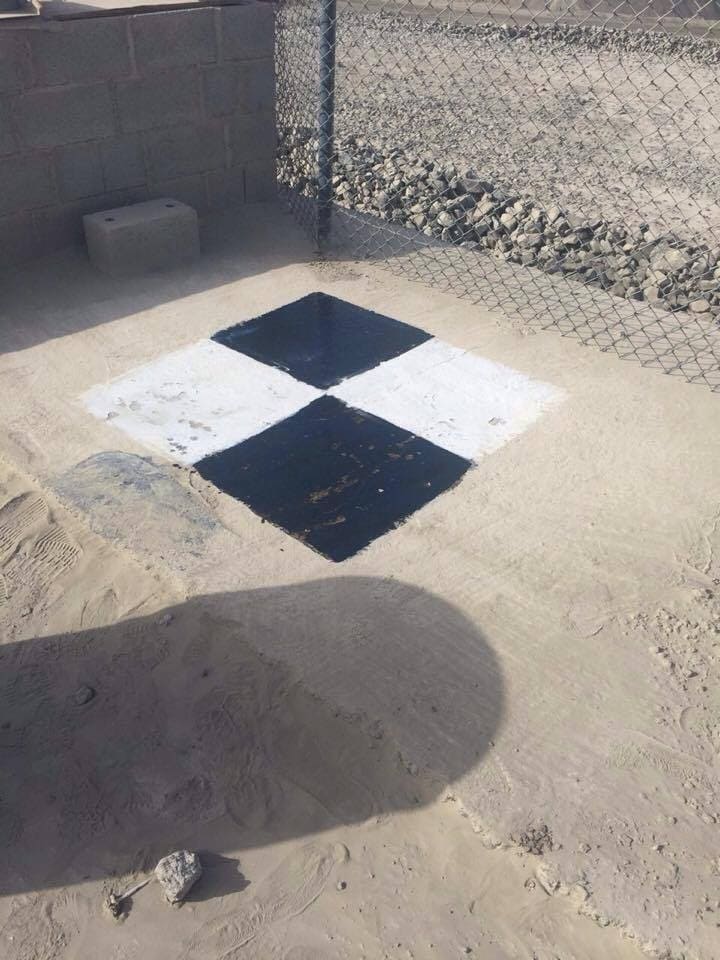
GCP stands for Ground Control Point. This is used as a reference and control point for a drone survey.
GCPs can be sprayed with paint as well as placed through solid targets. Their position is crucial for the quality of the measurement.
As in the photo, a GCP can be seen as a target on the ground whose position in a particular system is known. This position (of different GCPs) can be used to rotate a drone survey or a laser scan survey in a particular coordinate system, as well as to increase accuracy.
An essential part of using GCPs is that the GCPs are distributed “fairly” over the area to be measured. If this is not done, the survey may sometimes be skewed according to the location where too many or too few GCPs are placed.
GCPs also increase accuracy as the reference coordinates are known in a coordinate system with an accuracy of 1 to 2 cm (depending on the GNSS device used to measure the GCP). The average drone photo taken with a device without RTK has a position accuracy of about 5 meters. This deviation is corrected in the photogrammetric calculation. GCPs increase the accuracy of these calculations.
The use of GCPs can also ensure that a measurement is known in a certain coordinate system, such as the well-known Lambert72 system in Flanders.
However, this could also be done with a drone equipped with RTK, we will explain this in another blog post.
However, GCPs remain the most accurate tool during drone surveys because they provide certainty through a measured position on the ground with a specialized device.
RTK, on the other hand, is measured with a drone by a device that moves and hangs in the air, which also has its advantages and disadvantages.
Tip from Guillaume, manager of TOPO4D “Use a GCP that has one clear intersection or midpoint (with a lot of contrast, for example a chessboard tile like this Propeller Aeropoint). However, if you want to use spray paint, spray an L and consistently use the inner or outer corner to measure and mark in the photos.
Nowadays, most software such as PIX4D automatically recognizes GCPs and you no longer have to manually mark this in a project! This makes a big difference in terms of profitability in a particular project! “.
How many do you need? Theoretically, at least three (to properly orient, position and scale the model in all directions). However, with Topo4D we recommend using at least eight or nine of them, along with a few other identifiers that can be used as checkpoints. We explain this here. These ensure that we can check our measurements, the checkpoints are always independent of the calculated 3D model or the 3D point cloud.
What can I use to measure it in?
That depends solely on the desired accuracy. If you want to measure points via RTK (Real-Time Kinematic) this is done to a maximum of one to two centimeters of absolute accuracy. GNSS systems are available for this, including systems from Trimble or the Leica GS18I / GS18T (which we use ourselves). If you occasionally need a high accuracy of two centimeters, a device such as the Emlid reach is ideal. A complete set is already available from just over 700 euros. Feel free to contact us if you have any questions about this.
There are also solutions available that don’t require a GNSS pole, such as the Propeller Aeropoints mentioned earlier. These are Ground Control Points that contain a GNSS receiver. All you have to do is put down the Ground Control Points, turn them on and leave them there for at least 45 minutes. You can then retrieve them again and have the GNSS data sent to the cloud. This will give you accurate coordinates of your points that you can easily use in Pix4D.
So much for this brief description of what a GCP is, if you have any further questions please do not hesitate to contact us and we will do our best to assist you as soon as possible.
To provide the best experiences, we and our partners use technologies like cookies to store and/or access device information. Consenting to these technologies will allow us and our partners to process personal data such as browsing behavior or unique IDs on this site and show (non-) personalized ads. Not consenting or withdrawing consent, may adversely affect certain features and functions.
Click below to consent to the above or make granular choices. Your choices will be applied to this site only. You can change your settings at any time, including withdrawing your consent, by using the toggles on the Cookie Policy, or by clicking on the manage consent button at the bottom of the screen.
Functional Always active
The technical storage or access is strictly necessary for the legitimate purpose of enabling the use of a specific service explicitly requested by the subscriber or user, or for the sole purpose of carrying out the transmission of a communication over an electronic communications network.
Preferences
The technical storage or access is necessary for the legitimate purpose of storing preferences that are not requested by the subscriber or user.
Statistics
The technical storage or access that is used exclusively for statistical purposes.The technical storage or access that is used exclusively for anonymous statistical purposes. Without a subpoena, voluntary compliance on the part of your Internet Service Provider, or additional records from a third party, information stored or retrieved for this purpose alone cannot usually be used to identify you.
Marketing
The technical storage or access is required to create user profiles to send advertising, or to track the user on a website or across several websites for similar marketing purposes.
To provide the best experiences, we use technologies like cookies to store and/or access device information. Consenting to these technologies will allow us to process data such as browsing behavior or unique IDs on this site. Not consenting or withdrawing consent, may adversely affect certain features and functions.
Functional Always active
The technical storage or access is strictly necessary for the legitimate purpose of enabling the use of a specific service explicitly requested by the subscriber or user, or for the sole purpose of carrying out the transmission of a communication over an electronic communications network.
Preferences
The technical storage or access is necessary for the legitimate purpose of storing preferences that are not requested by the subscriber or user.
Statistics
The technical storage or access that is used exclusively for statistical purposes.The technical storage or access that is used exclusively for anonymous statistical purposes. Without a subpoena, voluntary compliance on the part of your Internet Service Provider, or additional records from a third party, information stored or retrieved for this purpose alone cannot usually be used to identify you.
Marketing
The technical storage or access is required to create user profiles to send advertising, or to track the user on a website or across several websites for similar marketing purposes.
var wcpt_i18n = {"i18n_no_matching_variations_text":"Sorry, no products matched your selection. Please choose a different combination.","i18n_make_a_selection_text":"Please select some product options before adding this product to your cart.","i18n_unavailable_text":"Sorry, this product is unavailable. Please choose a different combination.","lang":""};
var wcpt_params = {"ajax_url":"https:\/\/avpay.aero\/wp-admin\/admin-ajax.php","wc_ajax_url":"\/?wc-ajax=%%endpoint%%","shop_url":"https:\/\/avpay.aero\/marketplace\/","shop_table_id":"82332","site_url":"https:\/\/avpay.aero","cart_widget_enabled_site_wide":"","cart_widget_exclude_urls":"","cart_widget_include_urls":"","initially_empty_cart":"1","initial_device":"laptop","breakpoints":{"tablet":"1199","phone":"749"},"price_decimals":"2","price_decimal_separator":".","price_thousand_separator":",","price_format":"%1$s%2$s","currency_symbol":"\u00a3","responsive_checkbox_trigger":"1"};
var wcpt_persist_params = ["s","post_type","term","taxonomy"];
var wcpt_ti_wishlist_url = "
https://avpay.aero/wishlist/";
var wcpt_ti_wishlist_ids = [];
var mejsL10n = {"language":"en","strings":{"mejs.download-file":"Download File","mejs.install-flash":"You are using a browser that does not have Flash player enabled or installed. Please turn on your Flash player plugin or download the latest version from https:\/\/get.adobe.com\/flashplayer\/","mejs.fullscreen":"Fullscreen","mejs.play":"Play","mejs.pause":"Pause","mejs.time-slider":"Time Slider","mejs.time-help-text":"Use Left\/Right Arrow keys to advance one second, Up\/Down arrows to advance ten seconds.","mejs.live-broadcast":"Live Broadcast","mejs.volume-help-text":"Use Up\/Down Arrow keys to increase or decrease volume.","mejs.unmute":"Unmute","mejs.mute":"Mute","mejs.volume-slider":"Volume Slider","mejs.video-player":"Video Player","mejs.audio-player":"Audio Player","mejs.captions-subtitles":"Captions\/Subtitles","mejs.captions-chapters":"Chapters","mejs.none":"None","mejs.afrikaans":"Afrikaans","mejs.albanian":"Albanian","mejs.arabic":"Arabic","mejs.belarusian":"Belarusian","mejs.bulgarian":"Bulgarian","mejs.catalan":"Catalan","mejs.chinese":"Chinese","mejs.chinese-simplified":"Chinese (Simplified)","mejs.chinese-traditional":"Chinese (Traditional)","mejs.croatian":"Croatian","mejs.czech":"Czech","mejs.danish":"Danish","mejs.dutch":"Dutch","mejs.english":"English","mejs.estonian":"Estonian","mejs.filipino":"Filipino","mejs.finnish":"Finnish","mejs.french":"French","mejs.galician":"Galician","mejs.german":"German","mejs.greek":"Greek","mejs.haitian-creole":"Haitian Creole","mejs.hebrew":"Hebrew","mejs.hindi":"Hindi","mejs.hungarian":"Hungarian","mejs.icelandic":"Icelandic","mejs.indonesian":"Indonesian","mejs.irish":"Irish","mejs.italian":"Italian","mejs.japanese":"Japanese","mejs.korean":"Korean","mejs.latvian":"Latvian","mejs.lithuanian":"Lithuanian","mejs.macedonian":"Macedonian","mejs.malay":"Malay","mejs.maltese":"Maltese","mejs.norwegian":"Norwegian","mejs.persian":"Persian","mejs.polish":"Polish","mejs.portuguese":"Portuguese","mejs.romanian":"Romanian","mejs.russian":"Russian","mejs.serbian":"Serbian","mejs.slovak":"Slovak","mejs.slovenian":"Slovenian","mejs.spanish":"Spanish","mejs.swahili":"Swahili","mejs.swedish":"Swedish","mejs.tagalog":"Tagalog","mejs.thai":"Thai","mejs.turkish":"Turkish","mejs.ukrainian":"Ukrainian","mejs.vietnamese":"Vietnamese","mejs.welsh":"Welsh","mejs.yiddish":"Yiddish"}};
var _wpmejsSettings = {"pluginPath":"\/wp-includes\/js\/mediaelement\/","classPrefix":"mejs-","stretching":"responsive","audioShortcodeLibrary":"mediaelement","videoShortcodeLibrary":"mediaelement"};
var wc_order_attribution = {"params":{"lifetime":1.0e-5,"session":30,"ajaxurl":"https:\/\/avpay.aero\/wp-admin\/admin-ajax.php","prefix":"wc_order_attribution_","allowTracking":false},"fields":{"source_type":"current.typ","referrer":"current_add.rf","utm_campaign":"current.cmp","utm_source":"current.src","utm_medium":"current.mdm","utm_content":"current.cnt","utm_id":"current.id","utm_term":"current.trm","session_entry":"current_add.ep","session_start_time":"current_add.fd","session_pages":"session.pgs","session_count":"udata.vst","user_agent":"udata.uag"}};
var woosc_vars = {"ajax_url":"https:\/\/avpay.aero\/wp-admin\/admin-ajax.php","nonce":"a76abf8de2","hash":"oml3","user_id":"0cdb64fab32a05bd393b20c8c351de9f","page_url":"#","open_button":"","hide_empty_row":"yes","variations":"yes","open_button_action":"open_popup","menu_action":"open_popup","button_action":"show_table","sidebar_position":"right","message_position":"right-top","message_added":"{name} has been added to Compare list.","message_removed":"{name} has been removed from the Compare list.","message_exists":"{name} is already in the Compare list.","open_bar":"no","bar_bubble":"no","adding":"prepend","click_again":"no","hide_empty":"yes","click_outside":"yes","freeze_column":"yes","freeze_row":"yes","scrollbar":"yes","limit":"4","remove_all":"Do you want to remove all products from the compare?","limit_notice":"You can add a maximum of {limit} products to the comparison table.","copied_text":"Share link %s was copied to clipboard!","button_text":"Compare","button_text_added":"Compare","button_normal_icon":"woosc-icon-1","button_added_icon":"woosc-icon-74"};
var wc_cart_fragments_params = {"ajax_url":"\/wp-admin\/admin-ajax.php","wc_ajax_url":"\/?wc-ajax=%%endpoint%%","cart_hash_key":"wc_cart_hash_b6f0a4af5742f562436305e921d7ff3f","fragment_name":"wc_fragments_b6f0a4af5742f562436305e921d7ff3f","request_timeout":"5000"};
var tinvwl_add_to_wishlist = {"text_create":"Create New","text_already_in":"{product_name} already in Wishlist","simple_flow":"","hide_zero_counter":"","i18n_make_a_selection_text":"Please select some product options before adding this product to your wishlist.","tinvwl_break_submit":"No items or actions are selected.","tinvwl_clipboard":"Copied!","allow_parent_variable":"","block_ajax_wishlists_data":"","update_wishlists_data":"","hash_key":"ti_wishlist_data_b6f0a4af5742f562436305e921d7ff3f","nonce":"f09dcba848","rest_root":"https:\/\/avpay.aero\/wp-json\/","plugin_url":"https:\/\/avpay.aero\/wp-content\/plugins\/ti-woocommerce-wishlist\/","wc_ajax_url":"\/?wc-ajax=tinvwl","stats":"","popup_timer":"6000"};
var wcfm_datepicker_params = {"closeText":"Done","currentText":"Today","monthNames":["January","February","March","April","May","June","July","August","September","October","November","December"],"monthNamesShort":["Jan","Feb","Mar","Apr","May","Jun","Jul","Aug","Sep","Oct","Nov","Dec"],"monthStatus":"Show a different month","dayNames":["Sunday","Monday","Tuesday","Wednesday","Thursday","Friday","Saturday"],"dayNamesShort":["Sun","Mon","Tue","Wed","Thu","Fri","Sat"],"dayNamesMin":["S","M","T","W","T","F","S"],"dateFormat":"MM dd, yy","firstDay":"1","isRTL":""};
var wcfm_core_dashboard_messages = {"product_approve_confirm":"Are you sure and want to approve \/ publish this 'Product'?","product_reject_confirm":"Are you sure and want to reject this 'Product'?\nReason:","product_archive_confirm":"Are you sure and want to archive this 'Product'?","multiblock_delete_confirm":"Are you sure and want to delete this 'Block'?\nYou can't undo this action ...","article_delete_confirm":"Are you sure and want to delete this 'Article'?\nYou can't undo this action ...","product_delete_confirm":"Are you sure and want to delete this 'Product'?\nYou can't undo this action ...","message_delete_confirm":"Are you sure and want to delete this 'Message'?\nYou can't undo this action ...","order_delete_confirm":"Are you sure and want to delete this 'Order'?\nYou can't undo this action ...","enquiry_delete_confirm":"Are you sure and want to delete this 'Enquiry'?\nYou can't undo this action ...","support_delete_confirm":"Are you sure and want to delete this 'Support Ticket'?\nYou can't undo this action ...","follower_delete_confirm":"Are you sure and want to delete this 'Follower'?\nYou can't undo this action ...","following_delete_confirm":"Are you sure and want to delete this 'Following'?\nYou can't undo this action ...","resource_delete_confirm":"Are you sure and want to delete this 'Resource'?\nYou can't undo this action ...","auction_bid_delete_confirm":"Are you sure and want to delete this 'Bid'?\nYou can't undo this action ...","order_mark_complete_confirm":"Are you sure and want to 'Mark as Complete' this Order?","booking_mark_complete_confirm":"Are you sure and want to 'Mark as Confirmed' this Booking?","booking_mark_decline_confirm":"Are you sure and want to 'Mark as Declined' this Booking?","appointment_mark_complete_confirm":"Are you sure and want to 'Mark as Complete' this Appointment?","add_new":"Add New","select_all":"Select all","select_none":"Select none","any_attribute":"Any","add_attribute_term":"Enter a name for the new attribute term:","wcfmu_upgrade_notice":"Please upgrade your WC Frontend Manager to Ultimate version and avail this feature.","pdf_invoice_upgrade_notice":"Install WC Frontend Manager Ultimate and WooCommerce PDF Invoices & Packing Slips to avail this feature.","wcfm_bulk_action_no_option":"Please select some element first!!","wcfm_bulk_action_confirm":"Are you sure and want to do this?\nYou can't undo this action ...","review_status_update_confirm":"Are you sure and want to do this?","everywhere":"Everywhere Else","required_message":"This field is required.","choose_select2":"Choose ","category_attribute_mapping":"All Attributes","search_page_select2":"Search for a page ...","search_attribute_select2":"Search for an attribute ...","search_product_select2":"Filter by product ...","search_taxonomy_select2":"Filter by category ...","choose_category_select2":"Choose Categories ...","choose_listings_select2":"Choose Listings ...","choose_tags_select2":"Choose Tags ...","choose_vendor_select2":"Choose Company ...","no_category_select2":"No categories","select2_searching":"Searching ...","select2_no_result":"No matching result found.","select2_loading_more":"Loading ...","select2_minimum_input":"Minimum input character ","wcfm_product_popup_next":"Next","wcfm_product_popup_previous":"Previous","wcfm_multiblick_addnew_help":"Add New Block","wcfm_multiblick_remove_help":"Remove Block","wcfm_multiblick_collapse_help":"Toggle Block","wcfm_multiblick_sortable_help":"Drag to re-arrange blocks","sell_this_item_confirm":"Do you want to add this item(s) to your store?","bulk_no_itm_selected":"Please select some product first!","user_non_logged_in":"Please login to the site first!","shiping_method_not_selected":"Please select a shipping method","shiping_method_not_found":"Shipping method not found","shiping_zone_not_found":"Shipping zone not found","shipping_method_del_confirm":"Are you sure you want to delete this 'Shipping Method'?\nYou can't undo this action ...","variation_auto_generate_confirm":"Are you sure you want to link all variations? This will create a new variation for each and every possible combination of variation attributes (max 50 per run)."};
var wcfm_params = {"ajax_url":"\/wp-admin\/admin-ajax.php","wc_ajax_url":"\/wp-admin\/admin-ajax.php","shop_url":"https:\/\/avpay.aero\/marketplace\/","wcfm_is_allow_wcfm":"","wcfm_is_vendor":"","is_user_logged_in":"","wcfm_allow_tinymce_options":"undo redo | insert | styleselect | bold italic | alignleft aligncenter alignright alignjustify | bullist numlist outdent indent | link image | ltr rtl","unread_message":"0","unread_enquiry":"0","wcfm_is_allow_new_message_check":"1","wcfm_new_message_check_duration":"300000","wcfm_is_desktop_notification":"1","is_mobile_desktop_notification":"","wcfm_is_allow_external_product_analytics":"","is_mobile":"","is_tablet":"","wcfm_ajax_nonce":"95b54a6f64"};
var wcfm_enquiry_manage_messages = {"no_name":"Name is required.","no_email":"Email is required.","no_enquiry":"Please insert your Enquiry before submit.","no_reply":"Please insert your reply before submit.","enquiry_saved":"Your Enquiry successfully sent.","enquiry_published":"Enquiry reply successfully published.","enquiry_reply_saved":"Your reply successfully sent."};
var wcfmu_products_manage_messages = {"no_title":"Please insert Product Title before submit.","no_excerpt":"Please insert Product Short Description before submit.","no_description":"Please insert Product Description before submit.","sku_unique":"Product SKU must be unique.","variation_sku_unique":"Variation SKU must be unique.","product_saved":"Product Successfully Saved.","product_pending":"Product Successfully submitted for moderation.","product_published":"Product Successfully Published.","set_stock":"Set Stock","increase_stock":"Increase Stock","regular_price":"Regular Price","regular_price_increase":"Regular price increase by","regular_price_decrease":"Regular price decrease by","sales_price":"Sale Price","sales_price_increase":"Sale price increase by","sales_price_decrease":"Sale price decrease by","length":"Length","width":"Width","height":"Height","weight":"Weight","download_limit":"Download Limit","download_expiry":"Download Expiry"};
let cmplzBlockedContent = document.querySelector('.cmplz-blocked-content-notice');
if ( cmplzBlockedContent) {
cmplzBlockedContent.addEventListener('click', function(event) {
event.stopPropagation();
});
}
var wcpa_front = {"api_nonce":null,"root":"https:\/\/avpay.aero\/wp-json\/wcpa\/front\/","assets_url":"https:\/\/avpay.aero\/wp-content\/plugins\/woo-custom-product-addons-pro\/assets\/","date_format":"F j, Y","time_format":"H:i","validation_messages":{"uploadPending":"Files are being uploaded.","validNumberError":"Provide a valid number.","formError":"Fix the errors shown above","checkCaptcha":"Tick the \"I'm not a robot\" verification","requiredError":"Field is required","allowedCharsError":"Characters %s is not supported","patternError":"Pattern not matching","minlengthError":"Minimum %s characters required","maxlengthError":"Maximum %s characters allowed","minValueError":"Minimum value is %s","maxValueError":"Maximum value is %s","minFieldsError":"Select minimum %s fields","maxFieldsError":"Select maximum %s fields","maxFileCountError":"Maximum %s files allowed","minFileCountError":"Minimum %s files required","maxFileSizeError":"Maximum file size should be %s","minFileSizeError":"Minimum file size should be %s","fileExtensionError":"File type is not supported","quantityRequiredError":"Please enter a valid quantity","otherFieldError":"Other value required","charleftMessage":"%s characters left","validEmailError":"Provide a valid email address","validUrlError":"Provide a valid URL","minQuantityError":"Minimum quantity required is %s","maxQuantityError":"Maximum quantity allowed is %s","groupMinError":"Requires minimum %s","groupMaxError":"Allowed maximum %s","uploadError":"Failed to upload %s","gt_translate_keys":["uploadPending","validNumberError","formError","checkCaptcha","requiredError","allowedCharsError","patternError","minlengthError","maxlengthError","minValueError","maxValueError","minFieldsError","maxFieldsError","maxFileCountError","minFileCountError","maxFileSizeError","minFileSizeError","fileExtensionError","quantityRequiredError","otherFieldError","charleftMessage","validEmailError","validUrlError","minQuantityError","maxQuantityError","groupMinError","groupMaxError","uploadError"]},"google_map_api":"","reCAPTCHA_site_key":"","recaptcha_v":"v2","ajax_add_to_cart":"","summary_order":["option_price","product_price","fee","discount","total_price"],"change_price_as_quantity":"1","show_field_price_x_quantity":"","disable_validation_scroll":"","gallery_update_field":"last_field","update_top_price":"","datepicker_disableMobile":"","radio_unselect_img":"","strings":{"place_selector_street":"Street Address","place_selector_city":"City","place_selector_state":"State","place_selector_zip":"Zip Code","place_selector_country":"Country","place_selector_latitude":"Latitude","place_selector_longitude":"Longitude","file_button_text":"Choose File","file_placeholder":"{count} Files","file_droppable_action_text":"Browse","file_droppable_desc_text":"or {action} to choose a file","file_upload_completed":"Completed","file_upload_failed":"Failed to upload","other":"Other","clearSelection":"Clear Selection","repeater_add":"Add Field","repeater_remove":"Remove Field","file_droppable_text":"Drag and Drop Files Here","to":" to ","gt_translate_keys":["place_selector_street","place_selector_city","place_selector_state","place_selector_zip","place_selector_country","place_selector_latitude","place_selector_longitude","file_button_text","file_placeholder","file_droppable_action_text","file_droppable_desc_text","file_upload_completed","file_upload_failed","other","clearSelection","repeater_add","repeater_remove","file_droppable_text","to"]},"i18n_view_cart":"View cart","options_price_format":"(price)","wc_price_format":"%1$s%2$s","hide_option_price_zero":"1","discount_show_field_price":"1","discount_strike_field_price":"1","discount_strike_summary_price":"1","discount_strike_total_price":"1","responsive_layout":"","product_price_parent_selector":".summary","accordion_open":"first_opened","accordion_auto_open":"","accordion_auto_close":"","woo_price_suffix":"","prices_include_tax":"1","isAdmin":"","cart_url":"https:\/\/avpay.aero\/cart-2\/","is_cart":"","user_roles":["guest"],"google_map_countries":"","init_triggers":["wcpt_product_modal_ready","qv_loader_stop","quick_view_pro:load","elementor\/popup\/show","xt_wooqv-product-loaded","woodmart-quick-view-displayed","porto_init_countdown","woopack.quickview.ajaxload","quick-view-displayed","update_lazyload","riode_load","yith_infs_added_elem","jet-popup\/show-event\/after-show","etheme_quick_view_content_loaded","wc_backbone_modal_loaded"],"wc_currency_symbol":"\u00a3","wc_currency_symbol_raw":"\u00a3","wc_thousand_sep":",","wc_price_decimals":"2","price_format":"%1$s%2$s","wc_decimal_sep":".","wc_currency_pos":"left","mc_unit":"1","addons":[],"upload_method":"normal"};
 7 AUGUST 2021
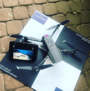 Tip from Guillaume, manager of TOPO4D


